

Jennifer Gray, CNN Meteorologist |CNN| Areas along the South Texas coast are under tropical storm alerts for a yet-to-form system that could start lashing the area with wind, rain and coastal flooding as soon as Tuesday morning.
This broad area of showers and thunderstorms in the central Gulf of Mexico is being called Potential Tropical Cyclone 9 by the National Hurricane Center because it has the potential to strengthen into a tropical depression or tropical storm but hasn’t yet done so. The designation allows the hurricane center to issue critical alerts warning of a storm’s arrival before it has technically formed.
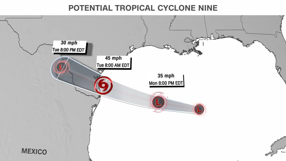
A tropical storm warning is in effect for portions of South Texas south of Port O’Connor and a tropical storm watch has been issued from Port O’Connor northward to Sargent. If it becomes a tropical storm, it could be named Harold, depending on whether another area in the Atlantic Ocean closer to Africa develops into a tropical storm first.
The system had 35 mph winds Monday afternoon and was moving to the west through the Gulf of Mexico at 16 mph. Rough seas, beach erosion, heavy rain, gusty winds and potential tornadoes will be possible from early Tuesday through Tuesday night.
Conditions in the Gulf of Mexico are ripe for tropical development right now. Sea surface temperatures in the Gulf of Mexico are warmer than they’ve ever been on record, according to analysis of NOAA data by hurricane expert Michael Lowry.
The water temperatures in the upper 80s give any budding tropical system the ability to thrive. There is also very low wind shear right now in the Gulf. Wind shear is what tears apart tropical systems, so without it, the storm could further develop and better organize.
With limited time for this storm to strengthen, most forecast models are keeping the system a weak tropical storm or tropical depression at landfall, however, with prime conditions in the Gulf, strengthening could occur.
“I’d certainly say that the system has some decent intensification potential before it hits land,” said Phil Klotzbach, research scientist in the Department of Atmospheric Science at Colorado State University.
Storm brings flood threat and drought relief
The system will bring heavy rainfall to the Texas coast as well as inland locations, regardless of its final strength. This could help a worsening drought affecting more than 70% of the state, but at the risk of flash flooding.

The latest track has the system heading due west and making landfall well south of Corpus Christi along the south/central Texas coast. This would mean the heaviest rain would fall south of Houston and Austin.
Corpus Christi could see as much as five inches of rain during the next few days as the system pushes inland. The hurricane center is forecasting as much as seven inches of rain for some isolated locations in South Texas and is urging residents to be prepared for flash flooding.
Up to two inches of rain will be possible from Austin to Del Rio, where temperatures have been off the charts this summer.
While this tropical system will bring some beneficial rain to parts of the drought-stricken state, some of the worst drought conditions – areas of extreme and exceptional drought in Central Texas – might miss out on the bulk of the rain.
Atlantic hurricane season exploding to life
The future tropical storm is the latest sign of the Atlantic hurricane season exploding into action. It’s almost as if a light switch was turned on in the Atlantic basin: three tropical systems formed in 24 hours Saturday into Sunday and now the Texas storm is expected to make it four.
This is only the third time on record three tropical systems have formed within 24 hours, according to Lowry.
While the Gulf system is the most imminent of the tropical threats, two other tropical storms are lined up in the Atlantic Basin.

Tropical Storm Franklin poses the biggest threat and is set to impact Hispaniola by mid-week. The storm currently has winds of 50 mph and is moving to the west at 12 mph. It is expected to make a hard turn to the north by Tuesday morning and make landfall in Hispaniola Tuesday night.
Tropical storm warnings are in effect for the southern side of Hispaniola, while tropical storm watches cover the northern side. There are also tropical storm watches for Turks and Caicos.
Rainfall amounts of 5 to 10 inches, with isolated higher amounts up to 15 inches, will be possible across portions of Hispaniola.
“The heavy rainfall may produce areas of flash and urban flooding as well as river rises and mudslides,” warned the hurricane center. Across Hispaniola significant and potentially life-threatening flash flooding is possible Tuesday into Wednesday.
The two other systems in the Atlantic don’t pose a risk to the US or the Caribbean. Gert is expected to fizzle out within the next 24 hours and Emily, which is much further out in the Atlantic, has already fizzled out as well.
The frenetic run of tropical activity is expected to continue. The eight-week span from mid-August through mid-October is when ocean temperatures are nearing their highest levels in the Atlantic, wind shear lessens considerably and when nearly 90% of all hurricane activity in the Atlantic happens.
“Of course, it remains to be seen what will happen following this flurry of activity, but given the NHC’s tropical weather outlooks, model projections and large-scale conditions, I expect the Atlantic will be quite busy through at least early September,” Klotzbach said.
More From Oklahoma Minerals: Diesel Is Pricing a Scarcity With Winter Demand Looming

